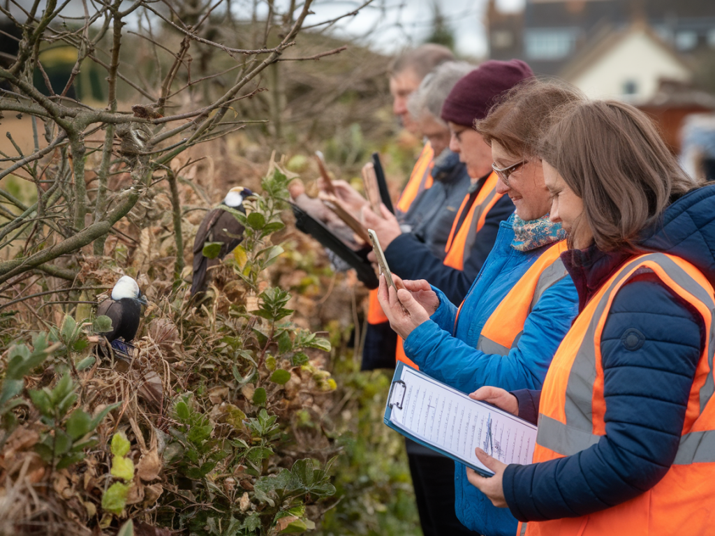
I’ve run a few village hedgerow surveys now and they’re one of my favourite low-effort, high-impact ways to get to know the patch of countryside I live next to. Hedgerows are linear wildlife corridors: they store history, feed birds and insects, and link habitats. With nothing more than a smartphone, a little planning and the right apps you can gather valuable ecological records and submit them to your local wildlife trust to help inform conservation and land management.
Why survey your hedgerow?
When I walk local lanes I often wonder what’s living in the hedges beyond the fields. A simple survey can tell you:
Which native trees and shrubs are present (hawthorn, blackthorn, hazel, elm, etc.).Whether hedges are species-rich or dominated by one type of plant.Signs of good management like layered structure, banks and gaps used by wildlife.Presence of priority species — veteran trees, protected plants, or important nesting birds and invertebrates.These records feed into local biodiversity datasets. Local Wildlife Trusts and county record centres use them to map habitat quality and to advise landowners. Your photos are often the proof ecologists need.
Planning the survey
Start small. I usually pick a single stretch of hedge (200–500 m) around the village, enough to spot variety without getting overwhelmed. Before you go:
Check access: most hedgerows beside public footpaths can be viewed and photographed from the path. If you need to cross private land, ask the landowner first.Decide on timing: late spring and early summer (May–July) is great for flowers and leaves, while autumn shows berries and fruiting structures. Do multiple visits across seasons if you can.Download useful maps/offline layers. Ordnance Survey maps, OS Maps app or the free Magic Map are helpful references.What gear I use
My hedgerow kit is deliberately light — a smartphone, a lightweight tripod and a small notebook. Here’s what I find useful:
Smartphone: Modern phones (iPhone 12/13/14, Pixel 5/6/7, Samsung S21+) have good cameras and GPS. The phone’s location and EXIF data are important.Macro lens attachment: A cheap clip-on macro (like those from Moment or generic brands) helps with flowers, buds and insect details.Small tripod or gorillapod: Useful in low light for sharper macro shots.Power bank: Keeps your phone alive if you’re doing long surveys.Apps: iNaturalist (or the UK equivalent iRecord/Record Pool), a GPS app (OS Maps, Gaia), and a note app or voice recorder.How to photograph for records
Good photos make the difference between a record being verified or rejected. I follow a few simple rules when photographing plants, trees and wildlife:
Capture multiple angles: For plants get a wide shot of the whole shrub or tree, a mid-distance shot showing context, and close-ups of leaves, flowers, fruit or thorns.Include diagnostic features: For hawthorn, for example, show leaves, blossom (if present) and fruit. For hedgerow trees show bark and branching for ID.Scale and context: Put a leaf next to a coin or your finger for scale, or photograph the hedge relative to the path/fence to show how continuous or gappy it is.Keep metadata: Ensure location services are on. Don’t crop out GPS or time data. Most smartphones embed coordinates in EXIF metadata which recorders use.Avoid over-editing: Slight exposure or contrast adjustment is fine, but heavy edits can remove crucial details and make verification harder.Recording structure and features
Beyond species IDs, I note structural features that tell a story about hedgerow age and management:
Is the hedge single- or double-row?Are there old standards (tall trees within the hedge)? Any veteran trees with hollow trunks?Is there a ditch or bank at the base — indicative of old boundary earthworks?Gaps and connectivity — are hedges continuous or fragmented?Signs of flailing vs. laid hedges — laid hedges often have greater wildlife value.Using apps and submitting records
There are a few routes to turn photos into useful records:
iNaturalist: Quick and great for community ID. Upload photos, add date and location (it usually reads EXIF), and the community suggests IDs. You can set accuracy and privacy settings to obscure precise locations for sensitive species.iRecord/Local recording scheme: In the UK, iRecord aggregates records and sends them to local county record centres and trusts. Create an account and upload your sightings; you can attach multiple photos per record and add notes.Direct to Wildlife Trust: Many Wildlife Trusts have pages where you can submit sightings or contact forms. If you’ve surveyed a whole hedgerow, email the trust with a short summary, photos, and a map — they may ask you to upload to iRecord or their own portal.When I submit large batches I usually:
Organise photos into folders by date and hedge section (e.g. “Green Lane Hedge — 2025-05-14”).Make a simple spreadsheet with species, grid reference (OS grid or lat/long), date, photos filenames and notes about structure.Upload via iRecord and link the spreadsheet in the message to the local trust so they have the overview.Data quality and sensitive species
Accuracy matters. When in doubt I mark an ID as “wildlife group” or “Acer sp.” rather than forcing a species name. For rare or sensitive species (e.g. protected orchids, badger setts, certain birds), follow local guidance: you may be asked to hide precise locations or contact the trust first.
Records without clear photos or vague locations may take longer to verify, so aim for clear images and accurate locations. If GPS on your phone is noisy, stand in the path next to the feature and take a quick screenshot of your map app showing the blue dot — that helps verifiers.
Working with the local Wildlife Trust
I always include a short cover note when I send a batch of records:
Who I am (volunteer walker/photographer).What hedge I surveyed (map link or OS grid reference).Dates of survey and whether it’s a single visit or repeated across seasons.Any management concerns (invasive species, recent flailing, opportunities for coppicing or planting).Local trusts are usually appreciative — they may use your data to prioritise habitat restoration, inform agri-environment advice to landowners, or add the hedge to a local ecological network map. Some trusts run volunteer training days too; offering to help with follow-up surveys can be a great next step.
Keeping it enjoyable and ethical
Surveying hedgerows should be low-impact. I stay on public paths, avoid disturbing birds (especially during the breeding season) and never handle protected species unless advised by professionals. Take time to enjoy what you find; some of my best records came from lingering and watching a corner of hedge through the day.
If you’d like, I can share my simple spreadsheet template or a checklist I use on walks — it makes repeat surveys faster and more useful for the people who will act on the data. Happy surveying — hedgerows hold more stories than you might think, and your photos can help them be told.